Depuis 28 Avril 2005
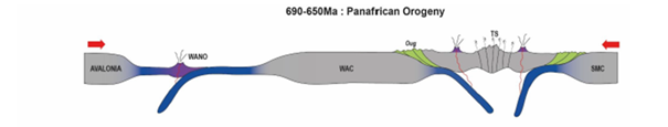
A 690-650 Ma
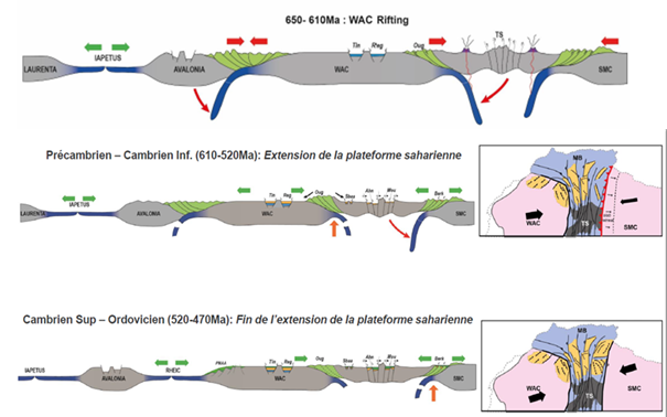
A 650 – 470 Ma
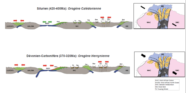
A 420 – 320 Ma
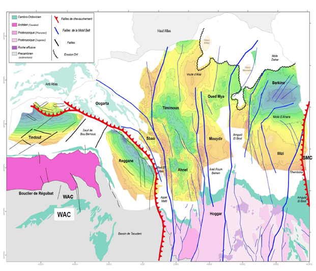
– The Tindouf/Reggane/Sbaa basins, associated with the West African craton, correspond to an extension of the crust.
superior and develop along normal faults. These are pericratonic basins located along the West African Shield
– The Ahnet/Timimoun, Oued Mya/Mouydir and Berkine/Illizi basins are the result of transtensive movements along the north-south faults inherited from the Pan-African chain. These pull-apart basins are bordered by sub-vertical faults. They are generally narrow and locally deep, and separated by structural highs.
These basins will therefore have different geometries and tectonic histories over time and depending on whether or not the various fault segments bordering them are activated.
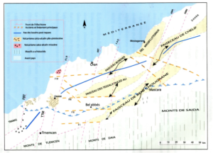
To the west, Tindouf and Reggane are two pericratonic basins whose geometry was shaped by the movements of the Reguibat shield, which dates back 2,500 million years (Archean) during various phases of deformation.
Bordered to the north and west by the West African Craton suture, they are separated by the Bou Bernous saddle, where the preserved series are not very thick.
To the north, the Tindouf basin is separated from the Timimoun basin by the Ougarta range, oriented N140° and composed of two main chains enclosing a perched basin (Sbâa basin), where the entire Palaeozoic series is preserved.
The Ougarta extends southwards through the Bled El Mas outcrop and then through the Azzel Matti, which separates the Reggane basin from the Ahnet.
Tindouf and Reggane mainly comprise Palaeozoic fill and a thin or absent Mesozoic series.
These are asymmetrical basins with a southern flank (Tindouf) and western flank (Reggane) rising gently towards the bedrock outcrops and a northern border (Tindouf) and east (Reggane) with very thick formations (Cambrian-Ordovician base at a depth of over 5,000 m) and deformed during the Hercynian phase with the creation of narrow folds aligned along the edges of the basins (EO north of Tindouf and N160° east of Reggane).
Finally, it should be noted that the formations of these two basins are invaded by intrusive rocks (dolerites, sills), whose presence is generally linked to the opening of the North Atlantic during the Lias.
These basins share characteristics common to intracratonic basins marked by the heterogeneities inherited from the bedrock: located north of the Hoggar, they reflect the division of this
The latter consists of large north-south panels that play like piano keys, ranging in age from the Palaeo-Proterozoic (2,000 Ma) to the Neo-Proterozoic (600 Ma). This heterogeneous bedrock heritage is the result of the Pan-African collision of two continents identified as the West African craton and the East Saharan craton.
The Palaeozoic formations extend structurally towards the south, where they outcrop at the edge of the Hoggar (Tassilis), and the basins are laterally limited by the extensions of the major faults cutting through the bedrock, which are associated with high axes mainly oriented NS.
These basins deepen towards the north, where they are extended beneath the Mesozoic cover by more subsiding basins that cut the platform into a complex whole, inherited from the structure of the substratum and replayed during all the major deformation phases of the Palaeozoic and Mesozoic-Cenozoic eras.
– The Ahnet basin, bordered to the west by the positive trend of Azzel Matti – Bled El Mas and to the east by the Arak Foum Belrem fault, extending northwards along the positive axis of Idjerane, then along the Allal Arch: this basin continues northwards through the Timimoun basin, whose main orientations gradually shift from NS to N160°, reflecting the influence of the Ougarta ranges to the west associated with the boundary of the West African Craton,
–
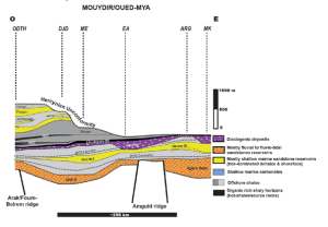
The Mouydir basin, located between the positive trends of Arak Foum Belrem Idjerane in the west and Amguid El Biod in the east. To the north, Mouydir extends into the Oued Mya basin, where the structural orientations gradually shift from NS to N30°.
The Illizi basin, located between the NS axes of Amguid El Biod in the west and Tihemboka in the east. It extends northwards, beyond the east-west Ahara pier, through the Berkine basin, which also extends into Libya (Ghadames basin), where the main orientations are N30°. The repetition of the structural configuration of these basins highlights the importance of the pan-African heritage. The presence throughout these basins of Palaeozoic series varying from continental facies in the south to more marine facies in the north reflects an almost permanent proximal to distal polarity throughout the Palaeozoic.
These basins are clearly delineated in their spatial extent by well-defined anticline axes in all directions, with the exception of Berkine in the east, which is bounded by the border.

To the south, connections with the basins backing onto the Hoggar can be made via high areas such as the Djoua saddle between Ahnet and Timimoun and the Môle d’Ahara between Illizi and Berkine.
They deepen rapidly and can reach depths of up to 5,000 m in Timimoun and 6,000 m in Berkine.
It is also worth mentioning the presence of Mesozoic cover on these three basins, which is thin on the Timimoun basin, except for its northern end at the Benoud Fault. The thickness of the Mesozoic increases significantly in the Oued Mya basin (3,000 m) and the Berkine basin (3,500 m). Finally, at the base of the Mesozoic, Triassic sandstone reservoirs develop under a Triassic to Lias salt cover, which constitute the elements of the petroleum system of the Hassi R’Mel deposits northeast of Timimoun, Haoud Berkaoui in the heart of Oued Mya and the main deposits of the Berkine Basin (Rhourde Nouss – Ourhoud – El Borma trend).
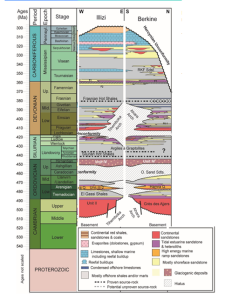
L‘histoire des bassins de Berkine et d‘Illizi est intimement liée jusqu‘au Dévonien et la mise en place définitive du Môle d‘Ahara qui sépare les deux bassins. Il existe une continuité sédimentaire observée au Silurien entre ces deux zones
Le bassin d‘Illizi, au Sud, contient des dépôts dits « proximaux » et le bassin de Berkine, plus subsident, au Nord, des dépôts dits « distaux ». En effet, les apports sédimentaires provenaient principalement du sud et du massif du Hoggar avec une faible vitesse de sédimentation estimée à 10 m/MA, typique des bassins intra-cratoniques.

Geological and structural framework:
The Illizi Basin is a stable platform basin covering an area of 100,000 km; its sedimentary cover has an average thickness of 3,000 m and consists mainly of Palaeozoic deposits.
Numerous tectonic events affected the Illizi Basin from the Precambrian to the Tertiary periods. The primary tectonic phases that caused the main faults and unconformities are:
Pan-African compressional events in the Precambrian period: these caused deep north-south faults rooted in the bedrock and their associated faults
The Hercynian movements, from the Carboniferous to the Permian: these mainly resulted in significant erosion and tilting of the basin; few fault sets or structural deformations can be dated to this period, unlike what is observed in the south-western basins.
Triassic-Lias: the opening of the Tethys and then the North Atlantic reactivated previous normal faults in the south and generated new faults further north in the Rhourde Nouss region and in the Berkine basin.
During the Cretaceous period, the shift in the rotation pole of the African plate generated particularly acute EW compression on the Amguid El Biod mole and slightly less compression in the centre of the Illizi basin.
During the Tertiary period, Alpine compressive phases reactivated ancient faults and reshaped structures;
the significant uplift of the Hoggar tilted the basin northwards, giving it its
Stratigraphic aspects:
Resting on a Precambrian crystalline-metamorphic base (which is believed to be of the same nature as that of the Hoggar), the sedimentary series forming the Illizi basin are mainly of Palaeozoic age, buried in the centre of the basin and outcropping in the south-east and on the southern margin of the basin at the Tassilis. The thickness of these series varies from the south (1,000 m to 1,500 m) to the north (1,500 m to 2,000 m). The Mesozoic deposits, on the other hand, are eroded in the southern half and outcrop in the centre of the basin, forming a succession of east-west-trending cliffs, where they lie unconformably on the Palaeozoic strata and are nearly 1,000 m thick.
Tertiary deposits are mainly found in the north-western part of the basin and in the Hamada du Tinrhert; Quaternary deposits are represented by dunes marking the southern boundary of the Grand Erg Oriental.